| Gunbarrel Highway distance table |
| East to West |
Place |
West to East |
Cumulative
distance (km) |
Point-to-point
distance (km) |
Point-to-point
distance (km) |
Cumulative
distance (km) |
| 0 |
- |
Wiluna |
283 |
1401 |
| 283 |
283 |
Harry Johnston Water |
67 |
1118 |
| 350 |
67 |
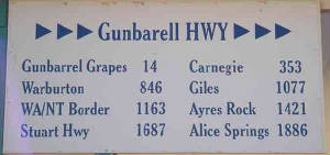
Carnegie Station |
151 |
1051 |
| 501 |
151 |
Eagle Highway crossroads |
54 |
900 |
| 555 |
54 |
Geraldton Historical Society Bore |
1 |
846 |
| 556 |
1 |
Gibson Desert Nature Reserve border |
31 |
845 |
| 587 |
31 |
Everard Junction (Gary Highway turnoff) |
8 |
814 |
| 595 |
8 |
Mount Everard side track |
33 |
806 |
| 628 |
33 |
Gibson Desert Nature Reserve border |
15 |
773 |
| 643 |
15 |
Mount Beadell side track |
35 |
758 |
| 678 |
35 |
Notabilis Bore |
25 |
723 |
| 703 |
25 |
Len Beadells Tree |
11 |
698 |
| 714 |
11 |
Gunbarrel/Heather Highway intersection |
84 |
687 |
| 798 |
84 |
Heather Highway/Laverton-Warburton Road intersection |
41 |
603 |
| 839 |
41 |
Warburton roadhouse
Central Australia (Warburton) Aboriginal
Land border |
213 |
562 |
| 1052 |
213 |
Gunbarrel Highway/Laverton-Warburton Road intersection |
16 |
349 |
| 1068 |
16 |
Giles Meteorological Station turnoff |
1 |
333 |
| 1069 |
1 |
Warakurna roadhouse |
29 |
332 |
| 1098 |
29 |
Gunbarrel Highway intersection |
36 |
303 |
| 1134 |
36 |
Schwerin Mural Crescent |
30 |
267 |
| 1164 |
30 |
Western Australia/Northern Territory border
Central Australia
(Warburton) Aboriginal Land/Petermann Aboriginal Land border |
10 |
237 |
| 1174 |
10 |
Kaltukatjara (Docker River) Community |
38 |
227 |
| 1212 |
38 |
Lasseters Cave |
135 |
189 |
| 1347 |
135 |
Petermann Aboriginal Land/Uluru-KataTjuta National Park border |
6 |
54 |
| 1353 |
6 |
Kata Tjuta turnoff |
15 |
48 |
| 1368 |
15 |
Kata Tjuta viewing area |
25 |
33 |
| 1393 |
25 |
Uluru turnoff |
8 |
8 |
| 1401 |
8 |
Yulara |
- |
0 |