Welcome to Carnegie Station

More to See

Home
Accomodation & Services
Extra Information
Our Location
About Us
Contact Info
More to See

The Gunbarrel Highway

From Carnegie Station in the West to Victory Downs Station near the Northern Territory  / South Australia Border.

Lorna Glen Conservation Park

A Dept of Environment & Conservation property formally the Lorna Glen Pastoral Station.

Earaheedy Station - D.E.C Conservation Area

A Dept of Environment & Conservation property formally the Earaheedy Pastoral Station.

Canning Stock Route

From Wiluna in the South Interior to Halls Creek in the Kimberly.

THE GUNBARREL HIGHWAY

The Gunbarrel Highway is an isolated desert track in the Northern Territory, South Australia and Western Australia, and it consists of 1400km of washaways, heavy corrugations, stone, sand and flood plains. The Gunbarrel Highway connects Victory Downs, just north of the Northern Territory/South Australia border to Carnegie Station in Western Australia (this is the direction the road was constructed). Some sources also incorrectly show the highway extending west to Wiluna.

The route passes directly into Aboriginal Reserves and it is a legal requirement for travellers to hold a valid Transit Permit at the time of travel. Three permits are required and they are available from the Department of Indigenous Affairs. The permits are free. Some of the eastern section of the road is now named the Tjukaruru Road for the Aboriginal people that live in this area.

The Gunbarrel Highway was the first road built as part of Australia's role in the weapons research facility called Woomera; the atomic bomb testing site in this area later named Maralinga. Construction began in 1955 and was finally completed on 15 November 1958 when the construction crew reached Carnegie.

The highway was surveyed and constructed under the direction of legendary bushman Len Beadell who was responsible for numerous other roads in Australia that opened up some of the most remote desert areas of the continent in the 1950s and 1960s. Its name comes from Beadell's Gunbarrel Road Construction Party so named because of much of the road's appearance.

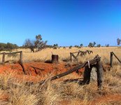
By any standard, this is a long and tough haul through very remote territory. 
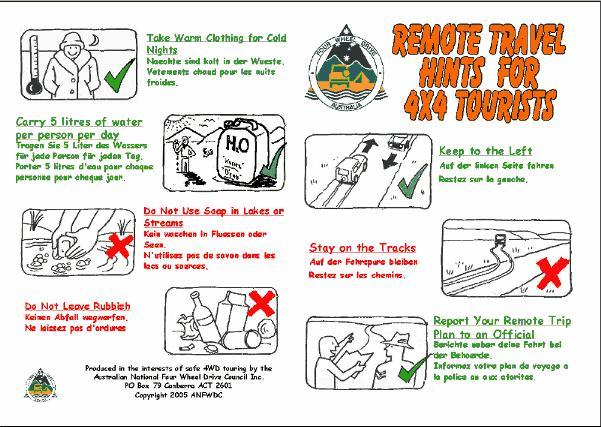
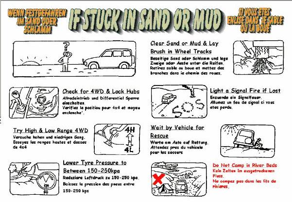
The track varies from stony to sandy with corrugations, ruts, washaways and sometimes mud. Its isolation require its residents be totally self-sufficient with water, food and fuel (the longest distance between fuel outlets is 489 km, between Warburton and Carnegie Station.)

The part of the highway approximately between Warburton and Warakurna has now been abandoned because of the construction of a more direct route that now forms part of the Great Central Road.

gunbarrel-highway.jpg

LORNA GLEN CONSERVATION PARK
Formally Lorna Glen Station
Located 160 kilometres N/E of Wiluna
Travel on Wongawol Rd for 44 km's, turn left onto Granite Peak Lake Violet Road, travel for 85km's, turn right onto Lorna Glen Road. Homestead is 31 km's to the East.
Camping & Bunk Style Accomodation Available.
Contact: Ranger  - Dept of Environment & Conservation @ Kalgoorlie (08) 9080 5555.
 

EARAHEEDY STATION CONSERVATION AREA
Formally Earaheedy Station
Located by Road approx 90 kilometres North of Lorna Glen
Main feature on this Conservation Area is the scenic picnic area at Sydney Head Pass.
To get there travel on Wongawol Rd for 44 km's, turn left onto Granite Peak Lake Violet Road, travel for 190 km's, approx 58 km's past turnoff to the Granite Peak Homestead. Just 40 km's South of Glenayle Homestead.
Earaheedy Station homestead is abandoned. No Facilities Available.
Contact: Ranger  - Dept of Environment & Conservation @ Kalgoorlie (08) 9080 5555.

THE CANNING STOCK ROUTE
 
The Caning Stock Route (CSR) is one of the most remote and isolated 4WD tracks in the world and holds it appeal as the "last frontier". This Trek Note contains extensive trip planning information for those that wish to travel self-sufficiently. The Canning Stock Route can be traversed from top to bottom or vice versa. The northern end is approached in the southern Kimberly, near the Billiluna Community on the Tanimi Track and as such is affected by wet season conditions throughout the Australian summer and often into Autumn. It is typical for the section containing Wells 36 - 51 to be extremely boggy and can even become impassable at the salt lake areas. Access is totally wearher dependant.

In times of wet weather
, the section between Wells 2 - 5 through Cunyu Station may be closed to all traffic. This section is also permanently closed to all vehicles towing trailers and "oversize" vehicles. i.e.., any wide track vehicle over the size of a Toyota Troopcarrier (PC) - definitely no Okas, or Akas. Alternative entry points are via private station tracks through Granite Peak (meets CSR Well 5 and Glenayle Stations (meets CSR at Well 9). From the south these tracks are approached from the Gunbarrel Highway or can be used as exit points off the Canning Stock Route for southbound travellers. Both stations charge a fee of approximately $20.

There are 2 alternative access/exit points to the Canning Stock Route being via either of the other 2 stations further to the north (near Well 5, and Well 9) accessed off the Wongawol Road (maintained by Wiluna Shire) about 50km to the east of Wiluna and CSR. Both these stations charge a small fee which is used for track maintenance. exploreoz.com:
www.exploroz.com/TrekNotes/WDeserts/Canning_Stock_Route.aspx

csr.jpg

Code of Conduct - Camping

Safety Card 1

Off Road Driving

Safety Card 2

Start of the Gunbarrel Highway - Heading East